Tel Maresha
Tel Maresha was an ancient city which was inhabited during the Iron Age as well as the Persian and Hellenistic periods. The ruins are located in the Shephelah region of the Judean Lowland, roughly 39km (24 miles) from Jerusalem.
During the Maccabean Wars (late 2nd century BC), the city was destroyed by Jewish rebels, then rebuilt at nearby Beit Guvrin during the Roman Period. Now a national park and a UNESCO World Heritage Site, the ruins of Tel Maresh include fascinating artificial caves and cavities hewn out of soft chalk beneath the city.
Tel Maresha in Biblical Times
The Hebrew People's Book of Books says that Maresha was part of the Kingdom of Judah. The book of Joshua carefully lays out the geography of the Promised Land when it was settled by the tribes of Israel,
"This is the inheritance of the tribe of the sons of Judah according to their families ... And Keilah, and Achzib, and Maresha" (Joshua 15:20, 44).
Maresha was founded in the 9th century BC and fortified by King Rehoboam of Judah.
"Rehoboam lived in Jerusalem, and surrounded the cities in Judea with walls ... He fortified ... And Gath, and Maresha, and Ziph ..." (II Chronicles 11: 5,6,8).
Around 900 BC, King Asa of Judea waged war against a formidable army of a million enemy warriors in the vicinity of Maresha.
"And Zarai (Zerah in Hebrew) set out against them . An Ethiopian with an army of one thousand thousand and three hundred chariots (probably Egyptian and Libyan mercenaries); and he reached Maresha. And Asa marched against him, and formed up for battle in the valley of Cefat near Maresha. And Asa called to the Lord his God, and said: Lord, is it not in your power to help the strong and powerless? Help us, Lord, our God, for we trust in you, and in your name we went out against this multitude. You are our God: let not man overcome you. And the Lord smote the Ethiopians before Asa and before Judah, and the Ethiopians fled" (II Chronicles 14: 9-12).
Micah, one of the 12 "minor" biblical prophets, also had a lot of God's verbs.
At the end of the 8th century BC, he mentions Maresha and other fortified cities of Judea. Micah describes the conquest and destruction inflicted on Judea by the Assyrian general Sennacherib in 710 BC.
"I will also bring an heir to you, inhabitant of Maresh; he will pass as far as Oddolam, the glory of Israel" (Micah 1:15).
The Hellenistic Period (4th to 2nd centuries BC)
During the period of Greek expansion in Judea which is known as the Hellenistic Period, the city of Maresha was renamed Marissa. Most of the ruins of buildings discovered by archaeologists in the lower part of the city belong to this period which confirms that the city flourished during this time period of the 4th to 2nd centuries BC.
Marissa was actively inhabited by the pagan people, the Sidonians and Edomites. Sidon was an glorious ancient city located in the territory of the modern state of Lebanon which borders Israel in the north.
According to the biblical narrative, Sidon was the son of Canaan and the grandson of Ham whose father was Noah. The Sidonians were one of the Canaanite tribes who inhabited the land of Canaan and Lebanon in ancient times. The Greeks called the inhabitants of Lebanon Phoenicians and there is no consensus among historians as to which ethnic group is identified; that is, whether the Canaanites and Phoenicians were one and the same people.
The Edomites were a people who lived in the Negev desert in modern day southern Israel. The name of their kingdom, Idumea, also comes from Greek although it was called Edom in the Bible. Edom and his people were sworn enemies of the Israelites and the descendants of Esau (Edom, which means red), Jacob's twin brother.
The Maccabean Period (2nd to 1st century BC)
In the 2nd century BC, Marissa was conquered by a descendant of the Maccabean dynasty, King John Hyrcanus (134-104 BC) and once again became a Jewish city and most of the pagan population fled the city. This conquest was the fulfillment of the prophecy of the biblical prophet Obadiah when he foretold,
"And on Mount Zion there will be salvation, and it will be holy; and the house of Jacob will receive his inheritance for possession. And the house of Jacob will be fire, and the house of Joseph will be fire, and the house of Esau (the Edomites) will be straw: they will burn it and destroy it, and no one will remain from the house of Esau: for the Lord has spoken this, and those to the south (the inhabitants of Judah) will take possession of Esau's mountain....." (Obadiah 1: 17-19).
Jewish historian Josephus Flavius confirms the return of the city to the Jews in his work, Jewish Antiquities. Edomite towns and villages (the area around Hebron and Beer Sheva) were converted to Judaism by the Hasmoneans,
“Hyrcanus also took Dora and Marissa, the cities of Idumea, and subdued all the Edomites; and allowed them to stay in this country if they circumcise their genitals and use the laws of the Jews; and they were so eager to live in the land of their ancestors that they submitted to circumcision and the rest of the Jewish way of life; at that time it dawned on them that they were none other than Jews" (13 9: 1).
Tel Maresha
The national park is located in the transitional area between the Mediterranean climate and the desert climate which is very dry.
The annual amount of precipitation is about 400 mm (15 inches) per year.
Under these conditions, low Mediterranean vegetation grows, predominantly carob trees, black hawthorn, (Rhamnus lycioides) and Mastic trees (Pistacia lentiscus).
During the winter and early spring, the hills are filled with gorgeous blooms of the almond trees, anemones, cyclamen and other wild flowers and plants.
Where the nari crust has been removed thorns grow heavily, especially in ravines and steep slopes. Human activity, such as grazing and farming have damaged natural vegetation.
In the relatively hot and arid climate conditions, the groves are slowly recovering. Many trees, such as olive, pomegranate and fig, thanks to care and intervention within the park.
Olive trees have been planted here as a tribute to the oil industry which has existed for thousands of years.
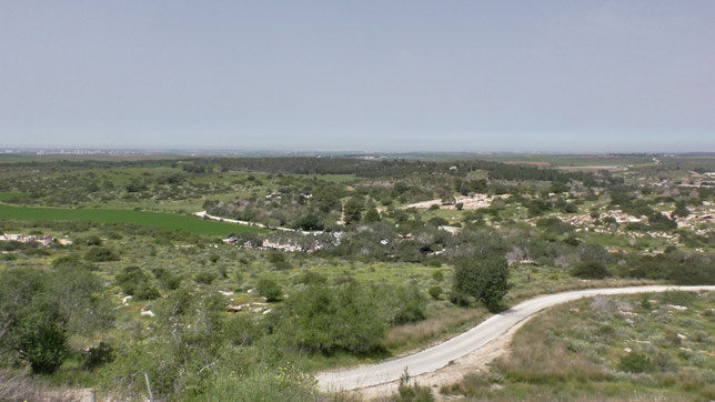
Tel Maresha is located on a high hill, 357 m (1172ft) above sea level and is elevated 30-40 m (98-131ft) above the surrounding area. The mound's surface area where the "Upper City" was located, is 24 dunams (6 acres). Surrounding the mound is the "Lower City", which covers an area of 320 dunams (79 acres). The dunam is an ancient unit of measure adopted from the time of the Turkish Ottoman Empire. One dunam equals approximately 1000 square meters (1/4 acre).
Caves of Tel Maresha
The bedrock of the local area is comprised of soft chalk which is several meters thick. Over this, there is a substantial layer of hard limestone locally known as nari , typically 9-12m thick (30-40ft). Once this stone is removed, the soft chalk can be easily dug out. Caverns were formed by making a hole in the ground and a square was cut from the limestone. A column was preserved while the depth and width were expanded as digging continued downward. After completion of the bell-shaped cave, niches were cut in the walls and the central block then the upper entrance was blocked off and a new entrance was added via a side staircase. The relative ease of digging into the soft chalk rock made it possible for many caves to be created in Maresh-Beit Guvrin.
In 1900, archaeologists Frederick Bliss (United States) and Robert McAlister (Ireland) explored an underground city which was found at the foot of the hills. They identified 63 underground complexes which were mapped and the number of associated rooms were documented. Since then, archaeologists have uncovered 162 additional cave complexes around Tel Maresh on all sides of the hill, but only a few are open to the public.
the bell cave
The bell Cave entrance


The Bel Cave inside


THE Polish Cave
The Polish (or Polskaya) Cave has dozens of niches (dovecotes) carved into the walls for pigeons which were raised in caves to supply fresh meat, eggs and droppings used for fertilizer. This type of structure is called a columbarium, from the Latin Colomba which means the family of pigeons. Originally from the Greek language, columbos means diver because pigeons can dive.
In ancient Judea, columbarium caves were especially widespread and there are 85 known columbarium caves in Tel Maresh alone, with tens of thousands of pigeon niches.
During World War II, Polish General Władysław Anders and his soldiers were stationed in the area and visited the cave and carved “1943”, the year of their visit, into a stone pillar, along with an inscription: “Warsaw, Poland” and the image of an eagle, the symbol of the Polish ground forces. The Polish army was originally created in the Soviet Union when Germany invaded. In March of 1942, based on an agreement between Great Britain, Poland and the Soviet Union, part of the Army was evacuated from the Soviet Union and transferred to Palestine.
Today, if you engrave your initials in the soft walls of the caves, instead of preservating your name down through history, you will have to pay a monetary fine.
THE Columbarium Cave


Next to Polish cave there is a larger structure which was a commercial columbarium. This cave was originally known by its Arabic name, "Es-Suk" (market), given by the locals. Today, it is called Columbarium and is the largest cave found in Tel Maresha. It was built with rectangular halls positioned in the form of a double cross, dating back to 3rd century BC and used until the 1st century AD. Originally, it was built as a columbarium but at the beginning of the 2nd century BC it was converted to into a warehouse for storing goods. There are over 2000 pigeon niches inside the cave.
During the second Jewish revolt known as the Bar Kokhba Revolt against Roman occupation (132-135 AD), the cave was used as a refuge for the rebels. A stepped corridor connects the cave to the surface. This exit in the western part of the center of the complex was discovered in 1990-1991.
THE Font Cave
This small cave dates back to the 3rd century BC and consists of a staircase and two small rooms used for bathing. The bather sat on a seat in one of the cells and a bath attendant poured water over the person who was hidden from view. It is possible this font cave served both hygienic and ritual purposes whose practices were often linked in antiquity.
THE oil press CAVE


Sydonian cave


To be continued...
The Story of the City of Beit Guvrin
Period of the Jewish wars
Eventually, the city of Beit Guvrin replaced Mareshа and this change was documented by historian, Joseph Flavius. According to his testimony, the city was destroyed by the troops of the Roman general Vespasian, although, despite the destruction, a large Jewish settlement continued to exist here until the Bar-Kokhba uprising, (132-135 AD)
roman period
In 200 AD, Emperor Septimius Severus changed the name of the city to a suitable Latin name, Eleoteropolis (translated free city). The inhabitants of the municipality lived in comfort brought about by the achievements of the Empire. Aqueducts supplied water, transport was advanced with wide, formal roads marked with pillars and an ampitheater which provided entertainment.
byzantine, arab and crusader PERIODs
During the Byzantine period (395 to 1453 AD), churches were built in the city, and most of the bell-shaped caves were dug out during the period of Arab settlement to provide chalk to scatter on the roads. During the period of the cross-bearers, the city was turned into a small fortress. St. Anne's Church was built in 1153 AD, during the time of the Crusaders.
Modern Period
In the 20th century, the Arab village existed until the 1948 War of Independence. British troops left the area halfway through the end of the mandate to rule Palestine.The abandoned fort, built by engineer Taggart, was immediately occupied by Egyptian troops until May 1949, when the Israeli armed forces liberated the area. An agricultural cooperative settlement (kibbutz) of the same name was established here.

Beit Guvrin amphitheater view

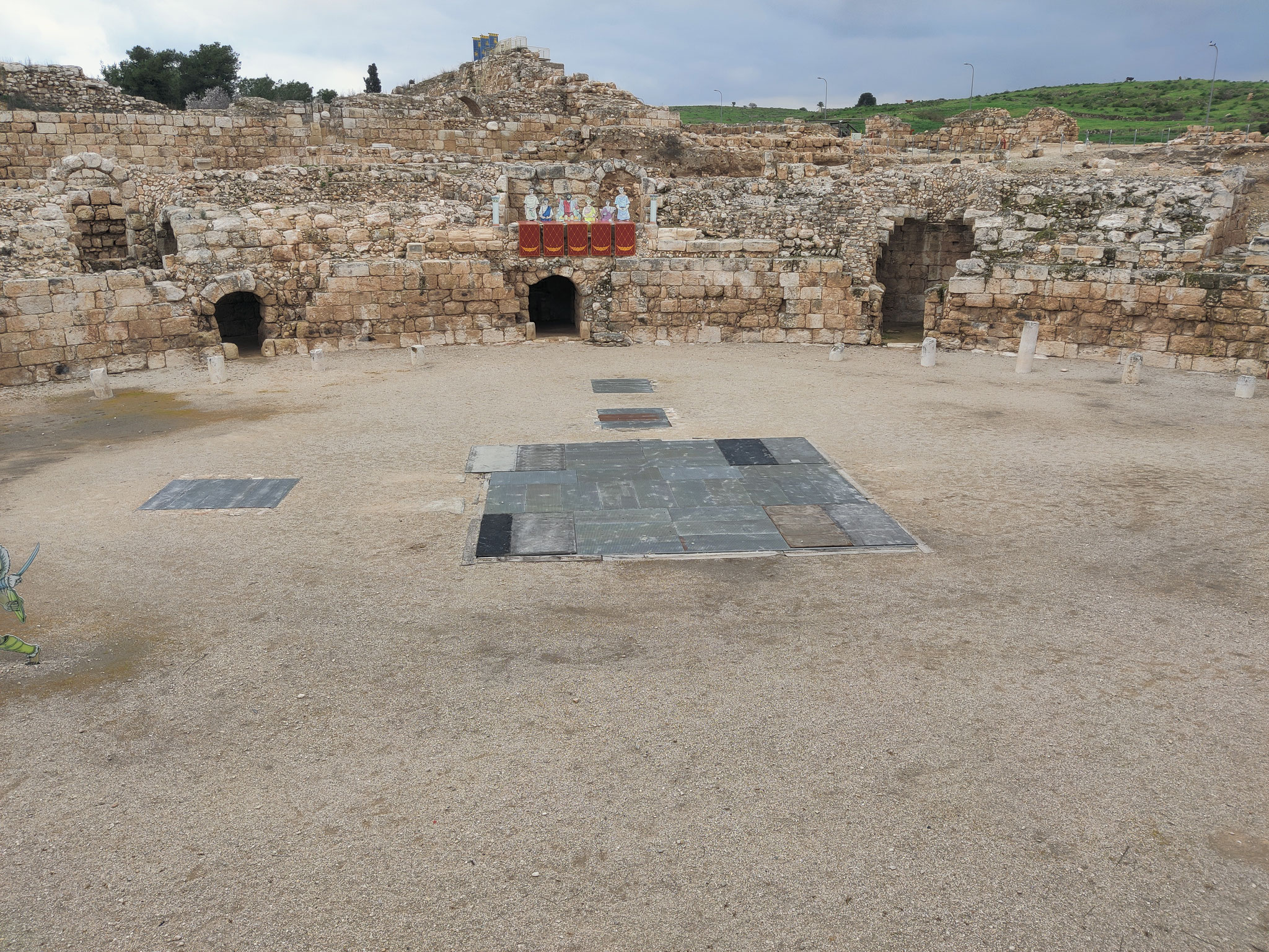


An amphitheatre is spelled in British English and this is actually closer to the original Greek spelling or amphitheater as it is called in American English is an open-air venue used for entertainment, performances, and sports. The term derives from the ancient Greek amphi, meaning "on both sides" or "around" and théātron, meaning "place for viewing".
Ancient Roman amphitheatres were oval or circular in plan, with seating tiers that surrounded the central performance area, like a modern open-air stadium. In contrast, both ancient Greek and ancient Roman theatres were built in a semicircle, with tiered seating rising on one side of the performance area.


